11.6 km², 22,000 images, 4 days, 1 computer: why DJI’s corridor mapping drone solutions shine when time and precision are of essence.
Water is the soul of Suqian, a prefecture-level city in China’s northern Jiangsu Province. With two rivers and two lakes flowing through it, Suqian has a rich cultural history, thriving aquaculture, and plenty of tourist attractions.
But until recently, the city of 138,500 residents also had a dirty secret. A secret called ‘Dragon Beard Ditch’. An important drainage channel in the old city center district, the Maling River, had fallen prey to industrial pollution.
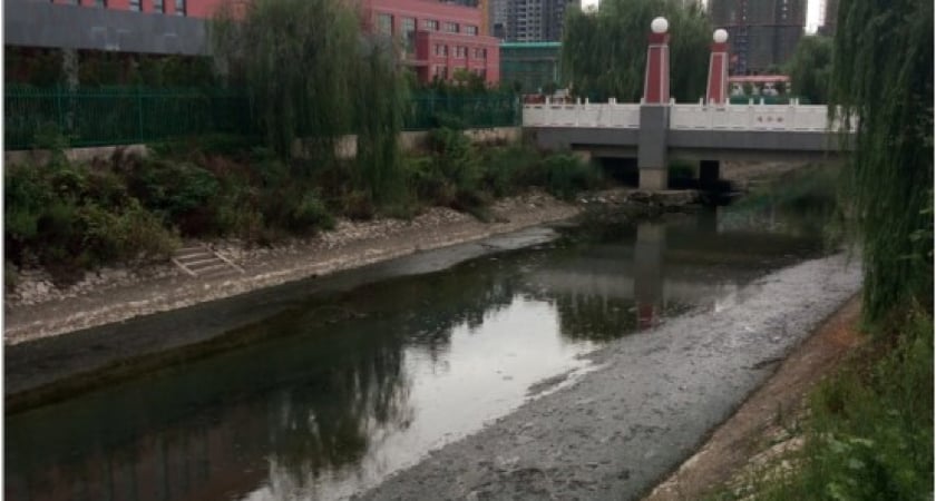
Maling river before cleanup.
Ecological restoration of a polluted river body
The 5.2km man-made Maling River corridor was created in 1974, with its total catchment area measuring 11.6 square kilometers. The Maling’s normal turquoise waters are being polluted with black sewage, leaving the surrounding residents frustrated and angry at the impact it has had on their everyday lives. An intervention was needed quickly in order to prevent what was unpleasant to look at from becoming a health and safety risk.
While the priority was to restore the river’s ecological health, it was also important that the restoration project could return Maling’s previous beauty to Suqian’s residents and visitors. Now that the cleanup operation is complete, the river has experienced a new lease of life thanks to a north-south promenade, clear waters and beautiful landscaping, allowing everyone to walk, sit and enjoy the surroundings once again.
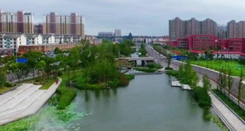
Maling river after cleanup.
Challenges of 3D river modeling in dense urban environments
It was decided that a thorough survey of the river corridor was required to maximise the positive impact of any work conducted and to aid future planning. The project was given a demanding 10 day completion deadline, AND it was stipulated that it must be completed in a cost-effective way.
There was no chance of completing the project within the time frame using a traditional surveying method, so the choice to use drones was an easy one. A less easy choice, however, was whether to use a fixed-wing or multirotor drone; fixed-wings can stay airborne for longer and cover larger areas quickly, whereas multirotor drones are more appropriate to fly at lower altitudes in urban environments.
Flight safety was very important for the Maling River corridor mission due to the constant presence of crowds of people and dense buildings. And when it came to capturing accurate data, negotiating buildings with varying heights meant that the drones’ flight path would have to be quite complicated.

Best way to map a river pulsing through a city?
After lots of market research, the DJI Phantom 4 RTK (now discontinued but superseded by Matrice 300 RTK and Zenmuse P1) was the chosen drone model thanks to its experience and credentials in digital mapping and surveying. The unit is portable and compact, and can capture highly accurate data in urban surroundings with relative ease.
The surveying team would then use DJI Terra, the all-in-one digital mapping software application which they would use for both mission planning and to create rich digital models in impressive 3D.
Intelligent flight planning with variable altitudes
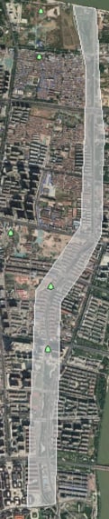
The first stage of the mission was to fly a P4RTK drone along the 5.2km length of the river to assess and record the heights of the buildings which line each side of the river. This data was then used to create an intelligent flight plan for the rest of the project. A flight path can be complicated by varying heights of obstacles like buildings, structures and trees, however the P4RTK can be programmed to fly at varying altitudes without sacrificing accuracy of data collection.
The ground sampling distance (GSD), the distance between each sample point taken of the ground, was set according to the flight path. Where the surrounding buildings were shorter, the height and GSD were set at 73m and 2cm respectively, whereas they were changed to 108m and 3cm respectively where buildings were taller.
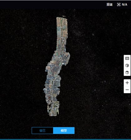
Urban river survey: 22,744 photos, 72 flights
With the flight plans determined and programmed, the data was collected in 3 days. Two pilots flying P4RTKs flew simultaneously throughout the day, equating to 7 hours of flight time per day. In total, 72 flights were undertaken which, combined, captured 22,744 images. This was then taken to the office team who, using DJI Terra, were able to create a 3D model – an 18GB data file – within just a few clicks.
Within 4 days, a ready-to-use model of the corridor had been created. The team producing the model did it with just one computer, running an Intel Core i7 CPU with 64GB memory.
Completing complex surveying missions ahead of time
Regardless of a challengingly short deadline and limited budget, the entire project was completed in 7 days – 3 days ahead of schedule. The team conducting the survey were able to do so due to several key factors.
Out of the box surveying solution
There is a reason why Phantom 4 RTK is considered to be the “gold standard” out-of-the-box drone for surveying. Its built-in real-time kinematic (RTK) functionality provides centimeter-level positioning data in real time, which is instrumental in generating precise 3D models; this meant that, essentially, surveys can be completed without any ground control points.
The P4RTK is also highly portable, making it ideal for surveyors who are always on the move and for whom survey efficiency is the number one priority.
Simple, one-click corridor mapping recipe
Because you can conduct a survey with a P4RTK drone using a pre-programmed flight path AND quickly and easily process the data in DJI Terra, surveys can essentially be completed in two clicks – one to start the flight, one to start the data load. The reduction in labour required to carry out a project can help surveyors work with new, unprecedented levels of efficiency.
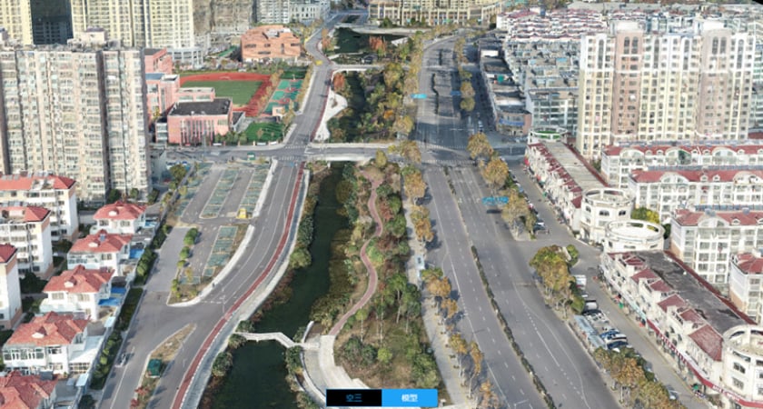
A 3D model of the Maling river created with DJI Terra.
400% more efficiency in drone data processing
With the solution used for the Maling River corridor project, surveyors can collect far more data in far less time thanks to their hardware (P4RTK) and software (DJI Terra) being seamlessly integrated. The most up-to-date version of DJI Terra can also process 400 photos from its partner P4RTK using just 1GB of memory – that’s 4 times (or 400%) more efficient than previous versions. Being able to complete a mission such as the Maling River project in such a short time can save surveyors team time, effort and money.
The road ahead…
Restoring the ecological health of the Maling River has had significant benefits for the health and wellbeing of Suqian’s residents and for biodiversity. Other parts of the project included building a water park, a historical and cultural park and increasing the green areas lining the river by 145,000 square meters.
Thanks to DJI’s aerial surveying tools, the city is now in possession of a high-resolution, accurate 3D model of the river and the trees, buildings, shops, riverbanks, parks and bridges which line it. The model will not only be used to maintain the area’s new-found beauty but also provides a platform for future work and a knowledge-sharing tool for other similar projects.
Get started with DJI today
DJI provides powerful aerial solutions which businesses can invest in to work more efficiently, accurately, safely and profitably than ever before. For more information on DJI solutions for urban planning, download DJI’s Building an AEC & Surveying Drone Program Playbook.
If you are interested in the DJI Enterprise range and would like to know more, please contact Andrew Bird on 07376 609 910 or andrew.bird@syndico.net.
Article originally published by DJI Enterprise – https://enterprise-insights.dji.com/user-stories/river-corridor-mapping-dji-terra.